 |
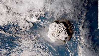
| Satellite images from JMA show the volcano eruption in Tonga on January 15. |
An undersea volcano near Tonga has erupted for the third time in four days, potentially threatening the ability of surveillance flights to assess damage to the Pacific island nation following Saturday’s massive eruption and tsunami.
The Australian Meteorological Service said a “major eruption” occurred on the Hunga Tonga Hunga Ha’apai volcano on Monday, but no tsunami warning was issued. Saturday’s eruption was probably the largest recorded on the planet in more than 30 years, experts said.
Dramatic footage from space captured the eruption in real time, when a huge plume of ash, gas and steam was spewed up to 20 kilometers (12.4 miles) into the atmosphere and Tsunami waves were sent to crash into the Pacific.
Footage on social media showed people fleeing as waves flooded Tonga’s capital, Nuku’alofa, and the afternoon sky turned black from the heavy ash cloud.
Tsunami waves have also been recorded thousands of miles away along the west coast of the United States, in Peru, New Zealand and Japan. In Peru, at least two people have died after being hit by high waves.
No mass casualties have yet been reported, but aid organizations are concerned about air contamination and access to clean water for residents of Tonga’s outer islands.
With communications down, Australia and New Zealand sent flights to survey the damage.
Where is Tonga’s Hunga-Tonga-Hunga-Ha’apai volcano?
Tonga is a Polynesian country of over 170 islands in the South Pacific and is home to around 100,000 people. It is a remote archipelago that lies about 800 kilometers (500 miles) east of Fiji and 2,380 kilometers (1,500 miles) from New Zealand.
The HungaTongaHungaHa’apai volcano, about 30 kilometers (20 miles) southeast of Tonga’s Fonuafo’ou Island, lies underwater between two small islands about 2,000 meters (6,500 feet) high from the sea floor, with about 100 meters (328 feet) visible above sea level.
Researchers said it has erupted steadily over the past few decades.
In 2009 an eruption sent plumes of steam and ash into the air and formed new land above the water, and an eruption in January 2015 created a new island about 2 kilometers wide , effectively merging with the islands of HungaTonga and HungaHa’apai.
The most recent eruption began in December 2021, with plumes of gas, steam and ash rising about 12 kilometers (7.5 miles) into the air.
The volcano erupted again on January 14, and a massive eruption on January 15 sent shock waves around the world and triggered tsunami waves in the Pacific.
Where did the tsunami hit?
The eruption caused a tsunami on Tonga’s largest island, Tongatapu, with waves recorded at 1.2 meters (about 4 feet) near Nuku’alofa city flowing onto coastal roads and flooding properties on Saturday.
Tsunami warnings went into effect across Pacific Island nations including Fiji, Samoa and Vanuatu. Footage from the ground in Fiji shows people fleeing to higher ground in the capital, Suva, as large waves hit the coast.
Tsunami warnings and advisories were also issued from parts of New Zealand, Japan and Peru, to the United States and Canada’s British Columbia.
In Japan, the northeastern prefecture of Iwate saw waves as high as 2.7 meters (9 feet) and multiple smaller tsunamis were reported in numerous other locations, according to public broadcaster NHK. By Sunday afternoon, all tsunami advisories had been lifted in Japan.
The eruption also sent waves to the US West Coast, with some exceeding 3 and 4 feet in height, according to the National Weather Service office in San Diego. Tsunami waves were felt in California, Alaska and Hawaii.
What is happening with the ash cloud?
A giant cloud of volcanic ash blanketed Tonga over the weekend, obscuring the afternoon sky and blanketing Nuku’alofa in a thick foam of volcanic dust on Saturday.
Save the Children said drinking water supplies could be contaminated with ash and smoke and the immediate concern in Tonga is air and water safety. The ash cloud was moving west and was visible over Fiji, Vanuatu and New Caledonia on Sunday.
According to the state weather service, it reached Queensland in Australia on Monday. at dawn sunlight was scattered by #volcanic ash from the #Tonga eruption,” the Queensland Bureau of Meteorology said on Twitter.
The ash prevented an Australian reconnaissance flight from departing to assess the damage early on January 17, although the flight took off later that morning.Several flights from Australia, New Zealand and Fiji to Tonga were postponed due to the ash cloud. suggest the volcanic ice eruption was the largest since the 1991 explosion at Mount Pinatubo in the Philippines, New Zealand volcanologist Shane Cronin told Radio New Zealand.
“This is a better observed eruption from space,” Cronin said, according to Reuters. The eruption suggests it was likely the largest since the Pinatubo eruption in 1991,” Cronin said.
What is the scale of devastation?
So far there have been no reports of mass casualties in Tonga and the extent of the damage is unknown as communications, particularly on the offshore islands, have yet to be restored.
Tonga “needs immediate help to provide its citizens with clean water and food”. said the Speaker of the country’s House of Representatives, Lord Fakafanua, in a statement released on social media.
It said “many areas” had been affected by “significant volcanic ash fall” but “the full extent of the damage to life and property is unknown at this time”. Prime Minister Jacinda Ardern said January 16 that tsunami waves had had a “significant impact” on Nuku’alofa as boats and large rocks washed ashore.
“Shops along the coast have been damaged and major cleanup will be required,” he said. The main underwater communications cable is also affected, likely due to a power outage. Australia’s Minister for Pacific and International Development Zed Seselja said there was “significant damage” in Tonga, including to roads and homes.
He said there was still “very limited, if any” information from the outer islands. The International Federation of Red Cross and Red Crescent Societies said its teams are on the ground and have enough supplies in the country to feed 1,200 homes.
“Based on what little current information we have, the extent of the devastation could be immense, particularly for the outer islands,” Katie Greenwood, head of the IFRC’s Pacific delegation, said, according to Reuters.
The New Zealand Defense Force sent an Orion aircraft on a surveillance mission to Tonga to assess the damage. Ardern said the country initially provided $340,000 for relief supplies, technical assistance and on-site assistance.
Australia said it was preparing for additional support, with a plane loaded with humanitarian supplies including water and hygiene items ready to deliver to Tonga as soon as conditions allow.
China and the autonomous island of Taiwan said in separate statements that they are ready to provide assistance at Tonga’s request.